-
If you are citizen of an European Union member nation, you may not use this service unless you are at least 16 years old.
-
You already know Dokkio is an AI-powered assistant to organize & manage your digital files & messages. Very soon, Dokkio will support Outlook as well as One Drive. Check it out today!
| |
Thunderstorms
Page history
last edited
by snodgrss@... 15 years, 4 months ago

Overview
Thunderstorms are one of Mother Nature’s most awesome weather phenomenon. Each day, thousands of thunderstorms rage across our planet bringing fierce winds, deadly lightning, hail, and tornadoes all while providing life-giving water to Earth’s soil. In the Northern hemisphere, especially in North America, thunderstorms occur most often between the months of March and September when warm, humid air is favorable frequently travels northward during the warmer months. Even through this time of year sees the most frequent thunderstorm activity; some places have thunderstorm activity all year long. Across the United States, they are most prevalent in the southeast and become more scarce as one moves to the northwest. During the summer months, in Florida, the thunderstorm capital of the United States, thunderstorms are nearly a daily occurrence.
 
One small thunderstorm can contain 900,000,000 gallons of water which is enough to cover an area of about 10 square kilometers with a half-an-inch of rain. The typical storm has a lifetime of about an hour and has the potential to cause many problems due to their strong winds, lightning, flooding, hail and tornadoes. Of these hazards, flooding is responsible for the majority of deaths caused by thunderstorms in the United States. Every year there is an average of 152 deaths and $12.5 billion worth of property and agricultural damage due to thunderstorms in the U.S. Although the destructive aspects of these storms focused on the most, the main benefit of these storms is the great water supply they provide for agriculture and human consumption.
Many people think that thunderstorms are just an ordinary daily weather phenomenon, when in reality, there is a lot that must occur for the formation of a thunderstorm. The three main ingredients that must come together for thunderstorm formation are an unstable atmosphere, a trigger mechanism, and surface moisture. For a thunderstorm to become severe the added ingredient of vertical wind shear is required. The National Weather Service requires one of the following to be considered severe: wind speeds of 50 knots (58 mph), hail that is ¾ inch, and/or tornadoes.
Although lightning is not part of the criteria for a severe, all thunderstorms contain lightning and thunder.
When the ingredients for severe thunderstorms come together, the National Weather Service issues a Severe Thunderstorm Watch. When a severe thunderstorm is actually occurring, a Severe Thunderstorm Warning is then issued. Many times, a tornado warning later follows a severe thunderstorm warning. If you hear a Thunderstorm
Watch or Warning, you should postpone all outdoor activities and get inside a safe and sturdy building.
There are various types of thunderstorms. There are Air Mass Thunderstorms (Ordinary Thunderstorms), MCS (Mesoscale Convection Systems) Frontal Squall Line Thunderstorms, and Supercell Thunderstorms. Although they for differently, they share a common life cycle. First, they begin in the Cumulus Stage, where the thunderstorm’s main updraft is formed. Once precipitation begins to fall and a well developed downdraft forms, the thunderstorm has entered the Mature Stage. The life cycle ends in the Dissipating Stage, where the updraft is cut off, the precipitation intensity decreases and the storm dies out.

|
Description
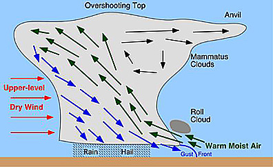
As a thunderstorm forms, the cumulonimbus clouds usually grow to heights above 20,000 feet. The height of a thunderstorm is controlled by the depth of the troposphere, because the layer above the troposphere, the stratosphere, is too stable to support a thunderstorm. This is the reason why many cumulonimbus clouds flatten into the classic anvil shape that marks a thunderstorm. [1] However, sometimes the momentum of the updraft of the storm may punch into the stratosphere and form a small overshooting top. This makes thunderstorms very tall, and most are so high that airplanes do not fly over them but instead fly around. If the airplane flew inside the thunderstorm, it would experience incredible turbulence from strong updrafts and downdrafts, destructive hail, and frequent lightning.

 The majority of thunderstorms are not severe, as the US National Weather Service reserves the term for thunderstorms that have hail the size of a penny or larger, winds of 58 mph or greater, or a tornado. Each year in the Unites States there are on average 20,000 to 30,000 reports of severe weather with typically around 12,000 from hail, 15,000 from severe winds and 1,200 from tornadoes. The majority of thunderstorms are not severe, as the US National Weather Service reserves the term for thunderstorms that have hail the size of a penny or larger, winds of 58 mph or greater, or a tornado. Each year in the Unites States there are on average 20,000 to 30,000 reports of severe weather with typically around 12,000 from hail, 15,000 from severe winds and 1,200 from tornadoes.
A type of thunderstorm that is usually not severe is an air mass thunderstorm. Commonly called “ordinary thunderstorms,” they usually occur within an air mass where there is very little vertical wind shear, causing the updraft and downdraft not to be separated and a short lifespan of around an hour. Air mass thunderstorms tend to form during the afternoon when warm rising thermals of air leave the earth’s surface to form cumulonimbus clouds, or when cool air outflows from other thunderstorms and triggers new thunderstorm formation. The precipitation of an air mass thunderstorm usually covers an area of 9-12 square miles, and although hail or tornadoes can develop they are generally not severe.

 Another type of thunderstorm is the mesoscale convective system (MCS), which produces the majority of the rainfall in the Central Plains. MCS are very large and can cover an entire state while producing damaging straight line winds. Straight line winds are any wind that is not rotating, the term is used to separate these winds from tornadoic winds. [2] Along the leading edge of the MCS there is an area of heavy precipitation that is typically between 3 to 9 miles wide, and following it is a wider area of less intense precipitation that can extend 60 to 120 miles behind the main line. MCS have long lifetimes, lasting many hours to days and have been known to occasionally produce weak tornadoes and hail but MCS are mostly linked to strong straight line wind damage. Another type of thunderstorm is the mesoscale convective system (MCS), which produces the majority of the rainfall in the Central Plains. MCS are very large and can cover an entire state while producing damaging straight line winds. Straight line winds are any wind that is not rotating, the term is used to separate these winds from tornadoic winds. [2] Along the leading edge of the MCS there is an area of heavy precipitation that is typically between 3 to 9 miles wide, and following it is a wider area of less intense precipitation that can extend 60 to 120 miles behind the main line. MCS have long lifetimes, lasting many hours to days and have been known to occasionally produce weak tornadoes and hail but MCS are mostly linked to strong straight line wind damage.
Supercell thunderstorms are the ones that produce the severe weather: tornadoes, large hail and damaging straight line winds. Although they are small in size, the supercell is highly destructive! The key distinguishing feature between the supercell and other thunderstorms is that they always rotate. [3] The rotating updraft of these storms, called the mesocyclone, fosters the development of tornadoes. These updrafts in supercells are very strong, they been measured at speeds over 100 mph. At such incredible vertical speeds, these storms have been known to support hail that is 5 to 7 inches in diameter and weighs as much as 2 lbs.
|
Formation
A severe thunderstorm requires four major elements to form: surface moisture, an unstable atmosphere, a trigger mechanism (lifting or heating of the surface), and wind shear. The organization of thunderstorms changes based on the trigger mechanism, the level of instability in an atmosphere, and the vertical wind shear. Most destructive thunderstorms develop in an environment that is very unstable atmosphere and has strong vertical wind shear. The lifting of the thunderstorm’s updraft commonly happens along fronts, which are boundaries located between two air masses. Strong fronts are often seen during the fall, winter, and spring months and pass with regularity across the United States. Lifting along the frontal boundary occurs as the front moves forward and warm, moist less dense air is thrust upward as the more dense air advances. The point where this occurs serves as a focal point for severe thunderstorm development, and the forward motion of the front often guides the storms on their path of destruction.
Ordinary thunderstorms experience three major stages of development. The first stage is called the cumulus stage where the cloud is formed as a warm plume of rising air, called an updraft, ascends into the lower troposphere. As the cloud rises to higher altitudes, the updraft velocity increases as well. In this stage, the clouds contain little or no raindrops or ice crystals, as they are made up of tiny cloud droplets too small to fall from the clouds. Small ice crystals start to form when the thunderstorm reaches an altitude with temperatures that range between -10 degrees C and -20 degrees C. Once these crystals are big enough, they start to fall through the storm.
The storm now enters the second stage, the mature stage. The precipitation goes through the cloud during this stage, and heads toward earth. The falling precipitation creates downdraft circulations in the center and upper parts of the cloud. Evaporation increases the downdrafts as the precipitation goes through entrainment, when precipitation collides with dry air near the edges of the cloud. The latent heat evaporation requires is provided by the air that has the precipitation in it. The air is cooled when the cloud and precipitation evaporates. The air then becomes denser which increases the downdrafts. The downdraft circulations go deeper in the cloud as the precipitation falls, and this offsets the updrafts that bring the warm air up from earth. Because there is not any wind shear, the wind speed does not increase with height, the updraft is not separated from the downdraft. The downdrafts that were created by evaporation and the drag force of the precipitation stop the updrafts. This, in turn, stops the supply of moisture for the storm.
During this time, the storm reaches its last stage, the dissipation stage. Air cooled from the rain and heavy rain fall from the bottom of the thunderstorm, which causes the storm clouds to evaporate, ending the thunderstorm. The development of new and current thunderstorms can be monitored through radar. From this radar you can see forecasts of where the storm might be headed to next.
  
|
Destruction
Thunderstorms have a vast arsenal of lethal and devastating weapons at their disposal. Mesoscale Convective Systems (MCS) and Supercell thunderstorms wreck havoc on human society through sudden explosive lightning strikes, 70 mph wind gusts, rampaging tornadoes, grapefruit-sized hailstones, and drowning floods. According to the NOAA’s National Weather Service, there were 1076 thunderstorm related fatalities from years 2000 to 2006 alone [2]. Over the same seven year time span, more than 22.3 billion dollars worth of property/crop damage was recorded. Such loss of not only tremendous amounts of capital, but also of human life has a profound impact on society. alone [2]. Over the same seven year time span, more than 22.3 billion dollars worth of property/crop damage was recorded. Such loss of not only tremendous amounts of capital, but also of human life has a profound impact on society.
Some of the worst thunderstorm related disasters that occurred in the U.S. are the Tri-State Tornado and the May 5th, 1995 Hailstorm in Fort Worth, Texas. The Tri-State tornado occurred on March 18, 1925. It originated in Ellington, Missouri and began its terrorizing 219 mile path northeast through southern Illinois and into Indiana. This single tornado completely destroyed over 15,000 homes, left at least 10 towns in ruins, and killed 695 people [3].


The May 5, 1995 hailstorm occurred in downtown Fort Worth, Texas during the Mayfest celebration [1]. A very rapid and unexpected supercell formation created 70 mph winds and rained 80 mph hailstones up to 3 inches in diameter. Shortly following the hailstorm, Fort Worth experienced flash flooding that left it swimming in two and a half to three feet of water. At least 14 people died, mostly due to the flash flooding. The damage for this single disaster totaled one billion dollars.


Thunderstorms affect the daily lives of people. They have the power to ruin scheduled events such as sporting events and outdoor functions. For the years 1990-2003, Florida has the highest death rates per year of lightning strikes while Colorado is a close 3rd in the number of lightning deaths. However, it is ranked a mere 24th in lightning flash density. This means that the number of people exposed to strikes, rather than the number of actual lightning strikes, correlates to lightning death rates. Both Florida and Colorado, areas of heavy outdoor activity, experience the highest amounts of lightning related deaths simply because the people there enjoy being outside.

Such large scales of devastation have a heavy impact on society. The dangers associated with thunderstorms have implored public education systems to teach students about thunderstorm safety. Also, the government intervenes along with the support from charities to provide relief for people after major thunderstorm related disasters. Regions typically associated with severe weather are economically affected by thunderstorms. Higher insurance rates and lower property costs are linked to thunderstorm prone areas.
Thunderstorms, despite their spectrum of chaotic destruction, have benefits for society. They can bring tremendous amount of rain and precipitation that drive agricultural growth. A small thunderstorm can contain over 900,000,000 gallons of water! Watering the thousands upon thousands of acres of crops would be nearly impossible without help from thunderstorms.
|
Vodcast
Fliqz has shut down their service. To access this video, email support with this video id: 5df113b3171648c6ab78918467d2fcba |
|
Case Study
On June 3, 2008, a stationary front had formed across the Midwest that separated a cool airmass covering most of Canada from a warm and moist airmass from the Gulf of Mexico which covered the Southern states. Low pressures formed along the boundary line between the two airmasses, which provided the trigger mechanism to lift the unstable air while also creating favorable wind shear. These ingredients came together to produce thunderstorm systems that would be responsible for heavy rain, incredible flooding, damaging tornadoes and strong straight-line winds across the Midwest. The heavy precipitation from these thunderstorm systems left anymore water from the heavy rain and this resulted in severe flooding in Indiana, Iowa and Wisconsin. Rivers and lakes overflowed their banks for several weeks at a time and broke through dams and levees. In Indiana, thirty thousand people lost power because of the storms, and several counties filed disaster declarations. In Wisconsin, at least ninety roads and highways were closed, three dams failed and four had water spill over, all because of the flooding caused by the thunderstorms. In Lake Delton, Winsconsin, at least three houses were swept away as lake water that had overflowed cut a new path through the town. Thousands of residents evacuated in 30 counties across the state because the flood waters had overtaken their community. The Red Cross opened shelters, and prison inmates and the military were dispatched to help with sandbagging. the ground in the Midwest saturated with moisture. The New York Times reported that by June 9, the ground could not absorb

 
All of this damage was not caused by one single thunderstorm, but because as mesoscale convective systems move, the cold pool produced spreads rearward and around the sides of the system which triggers the formation of new thunderstorm systems. So as the system moved across the Midwest, more and more thunderstorms were formed which caused the constant rain. These same thunderstorm systems also spun off tornadoes. According to the Storm Prediction Center, between June 3rd to the 13th, 217 tornadoes were confirmed, along with widespread straight–line wind wind damage. There were 289 reports of severe thunderstorm winds, most of which occurred along the squall line of the thunderstorm systems.


The Chicago Tribune reported that the flooding caused by these thunderstorms was the worst seen in the Midwest for 15 years and left 13 people dead. The strong flooding also exposed the vulnerability of the weak dams and levees that have not been maintained properly by the state or designed properly. The resulting damage from these storms was estimated to be in the tens of billions of dollars. 
|
Sources Used
Opening Statement—By Kara Klaisle
http://www.economics.noaa.gov/?goal=weather&file=events/
Severe & Hazardous Weather:
An Introduction to High Impact Meteorology
Second Edition
Robert M. Rauber, John E. Walsh, Donna J. Charlevoix
Description—By Caroline Holmes
Severe & Hazardous Weather:
An Introduction to High Impact Meteorology
Second Edition
Robert M. Rauber, John E. Walsh, Donna J. Charlevoix
http://www.weather.gov/glossary/index.php?letter=t
http://www.srh.noaa.gov/jetstream/tstorms/tstrmtypes.htm
http://www.srh.noaa.gov/jetstream/tstorms/life.htm
http://www.sky-fire.tv/index.cgi/thunderstorms.html#occur
Formation—By Lauren Heap
Severe & Hazardous Weather:
An Introduction to High Impact Meteorology
Second Edition
Robert M. Rauber, John E. Walsh, Donna J. Charlevoix
Destruction—Derek Wong
http://www.stormtrack.org/library/1995/hail.htm
http://www.weather.gov/om/hazstats.shtml
http://www.crh.noaa.gov/pah/1925/
Severe & Hazardous Weather:
An Introduction to High Impact Meteorology
Second Edition
Robert M. Rauber, John E. Walsh, Donna J. Charlevoix
Case Study
http://www.spc.noaa.gov/climo/reports/080603_rpts.html
http://archives.chicagotribune.com/2008/jun/11/news/chi-dams-flooding-jun12
http://www.spc.noaa.gov/climo/reports/080603_rpts.html
http://www.cbsnews.com/elements/2008/06/09/in_depth_nature/photoessay4163467_0_4_photo.shtml
http://www.timesdaily.com/article/20080610/ZNYT02/806100352
http://www.skywarn.ampr.org/newsletter_su_1996.html
|
Thunderstorms
|
|
Tip: To turn text into a link, highlight the text, then click on a page or file from the list above.
|
|
|
|
|


Comments (1)
Howie Leibach said
at 12:08 pm on Oct 1, 2008
Howie Leibach
You don't have permission to comment on this page.